|
Because you've got to know the world you live in
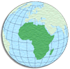 Africa Africa
The planet's 2nd largest continent, includes 53 individual countries. It contains
the Nile River, the world's longest, and the massive Sahara
Desert, the world's largest. The continent's highest point is Mt.
Kilimanjaro, in Tanzania, 19,341ft (5,895m), while the lowest point
is Lac' Assal in the small country of Djibouti, 512 ft (156m)
below sea level.
Algeria · Angola · Benin · Botswana · Burkina Faso
· Burundi · Cameroon · Cape Verde · Central African
Republic · Chad · Comoros · Congo · Congo (DRC)
· Cote d'Ivoire · Djibouti · Egypt · Equatorial
Guinea · Eritrea · Ethiopia · Gabon · Gambia ·
Ghana · Guinea · Guinea-Bissau · Kenya · Lesotho
· Liberia · Libya · Madagascar · Malawi ·
Mali · Mauritania · Mauritius · Morocco · Mozambique
· Namibia · Niger · Nigeria · Rwanda · Sao
Tome & Principe · Senegal · Seychelles · Sierra Leone
· Somalia · South Africa · Sudan · Swaziland ·
Tanzania · Togo · Tunisia · Uganda · Western Sahara
· Zambia · Zimbabwe
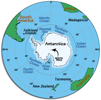 Antarctica Antarctica
This continent, almost completely covered with ice, has active territorial
claims submitted by Argentina, Australia, Chile, France, New Zealand, Norway
and the United Kingdom. (Many of these claims are not recognized by some countries
and remain in a constant disputed status). Antarctica is the coldest and windiest
spot on the planet. The lowest temperature ever recorded on Earth was recorded
in Antarctica (-129.3ºF) and the mean winter temperatures range from -40º
to -94ºF. Winds are commonly measured at up to 200 miles per hour. Antarctica
officially has no population, but governmental research stations are populated
with small groups of scientists at all times. In addition an estimated 8,000
tourists visit each year.
 The
Arctic The
Arctic
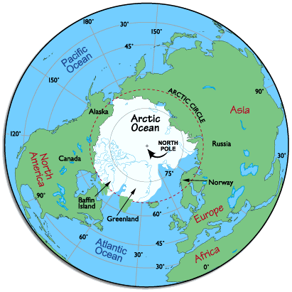
This region of the planet, north of the Arctic Circle, includes the Arctic
Ocean, Greenland, Baffin Island, other smaller northern islands, and the far
northern parts of Europe, Russia (Siberia), Alaska and Canada. The Arctic Circle,
incidentally, is an imaginary line located at 66º, 30'N latitude, and as
a guide defines the southernmost part of the Arctic. The climate within the
Circle is very cold and much of the area is always covered with ice.
In the mid winter months, the sun never rises and temperatures can easily
reach lows of - 50º F in the higher latitudes. In the summer months (further
south), 24 hours of sunlight a day melts the seas and topsoil, and is the main
cause of icebergs breaking off from the frozen north and floating south, causing
havoc in the shipping lanes of the north Atlantic.
The primary residents of the Arctic include the Eskimos (Inuits), Lapps and
Russians with an overall population (of all peoples) exceeding 2 million. The
indigenous Eskimos have lived in the area for over 9,000 years, and many have
now given up much of their traditional hunting and fishing to work in the oil
fields and the varied support villages.
The first explorers of the Arctic were Vikings. Norwegians visited the northern
regions in the 9th century, and Eric the Red (Icelander) established a settlement
in Greenland in 982. In 1909, after numerous attempts by regional explorers,
Robert E. Peary reached the North Pole.
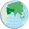
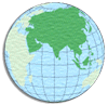 Asia Asia
As the planet's largest continent, Asia includes 44 countries and assorted
island dependencies. Significant features of the continent include the world's
tallest mountain, Mt. Everest in Nepal, at 29,035 ft (8,850m),
and the world's most populated countries, China and India.
The continent's lowest point is in the Dead Sea, Israel/Jordan,
at 1,286 ft (392m) below sea level.
Burma military authorities have promoted the name Myanmar since 1989 as the
conventional name for their state. This decision was not (and is not) approved
by any sitting legislature in Burma, and is not accepted by the U.S. government.
However, Myanmar is widely accepted by numerous countries, and by the United
Nations.
The Russian landmass west of the Ural Mountain is commonly referred to as
European Russia in most educational atlases, and by the vast
majority of geography experts. It is not a separate country, but rather called
that because of its political, cultural and geographical blendings with Europe.
However, the entire country (as a whole) is still considered part of the continent
of Asia.
Countries considered part of the Middle East are part of the
continent of Asia.
Taiwan is still considered by China to be its 23rd province, and not an independent
country. Very few other country governments accept China's claims of sovereignty
over Taiwan.
Turkey is officially, politically and geographically considered part of both
Asia and Europe. The small northwestern portion of Turkey named Thrace
is a recognized part of Europe, while the largest part (Anatolia)
is located in the Middle East, a part of Asia.
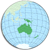 Oceania Oceania
Oceania, the smallest continent, is one of the most diverse and fascinating
areas on the planet. A large percentage of geography experts now consider the
long-established continent of Australia to be more accurately defined as Australia/Oceania.
Collectively it then combines all of Australia, New
Zealand, Papua New Guinea, as well as the thousands
of coral atolls and volcanic islands of the South Pacific Ocean, including the
Melanesia and Polynesia groups. Oceania also
includes Micronesia, a widely scattered group of islands that
run along the northern and southern edges of the Equator. The continent's highest
point is Mt. Wilhelm, Papua New Guinea at 14,794 ft (4,509m),
and its lowest point is at Lake Eyre, Australia, at 52ft (16m)
below sea level.
Melanesia includes the independent countries of Fiji
and Vanuatu, as well as the Solomon Islands
and New Caledonia.
Micronesia islands are all part of the same volcanic zone,
and include the Marshall Islands, the nation of Micronesia
(FSM), Nauru, Guam, Saipan
and the Northern Mariana Islands, as well as Palau
and Wake Island.
Polynesia contains numerous island groups, including all of
French Polynesia and the Austral, Gambier,
Marquesas, Society and Tuamoto islands.
In addition, the Cook Islands, Easter Island,
all of Kiribati, Niue, the Pitcairn
Islands, Tuvalu, and Wallis and Futuna.
Australia · Fiji · Grand Terre - New Caledonia · Guam
· New Caledonia · Northern Marianas · Saipan · Society
Islands · Tahiti · Tonga · Vanuatu
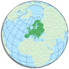 Europe Europe
Europe, the planet's 6th largest continent, includes 46 countries, and a few
dependencies, territories and regions. In exacting geographic definitions, Europe
is really not a continent, but part of the peninsula of Euroasia, which includes
all of Europe and Asia. However, most geographers today refer to it as an individual
continent. Europe is separated from Asia by Russia's Ural Mountains
in the east, and the Caspian and Black Seas
in the southeast.
Europe's highest point is Mt. Elbrus in European Russia at
18,481 ft (5,633m), just north of the Georgia/Russian border, and the continent's
lowest point is on the surface of the Caspian Sea, at 92 ft
(28m) below sea level.
Note: Turkey and the Russian Federation are considered a part of both Asia
and Europe.
Islands/Oceans
...
 The
Middle East The
Middle East
The Middle East (or West Asia) sits where Africa, Asia and Europe meet. The
countries of the Middle East are all part of Asia, but are sometimes shown geographically
a separate landmass.
Opinions vary as to what countries make up the modern definition of the Middle
East. Some sources consider Armenia and Azerbaijan to be part of the Middle
East, while most modern experts consider them a part of Europe.
The same can be said for the island country of Cyprus, For that matter, the
African country of Egypt is still thought (by some) to be in the Middle East,
as well as the northern African countries that border the Mediterranean Sea.
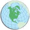 North
America North
America
North America, the 3rd largest continent, includes Canada,
Greenland, Mexico, the United States,
all the countries of Central America and the island countries
and dependencies of the Caribbean.
The continent's highest point is Mt McKinley, in Alaska,
at 20,322ft (6,194m), while the lowest point is Death Valley
in California, at 282 ft (86m) below sea level.
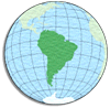 South
America South
America
South America, the planet's 4th largest continent, includes 12 countries and
3 major territories. The continent contains the Amazon River
and rainforest, the Andes Mountains, and some of the most spectacular
scenery on the planet. South America's highest point is at Cerro Aconcagua
in the Andes Mountains, Argentina at 22,833 ft (6,959m), and
its lowest point is at Peninsula Valdes on the Argentina coastline
at 151 ft (40m) below sea level.
Argentina · Bolivia · Brazil · Chile · Colombia
· Ecuador · Falkland Islands (a territory) · French Guiana
(a territory) · Galapagos Islands (a territory) · Guyana ·
Paraguay · Peru · Suriname · Uruguay · Venezuela
Reconstituted from information at http://worldatlas.com/
|